GNSS Positioning Technique
Introduction
This document provides brief overview of GNSS positioning concepts and techniques. The next few chapters will explain how GNSS positioning works, what is real-time kinematics concept and what are the figures of merit that can describe GNSS antenna and receiver performance.
GNSS (Global Navigational Satellites System) is a constellation of satellites providing signals from space that transmit positioning and timing data to GNSS receivers. The receivers then use this data to determine location. Examples of GNSS include USA’s NAVSTAR Global Positioning System (GPS), Europe’s Galileo, Russia’s Global'naya Navigatsionnaya Sputnikovaya Sistema (GLONASS) and China’s BeiDou. The advantage of having access to multiple satellites is accuracy, redundancy, and availability at all times.
The performance of GNSS is assessed using four criteria:

Global Navigation Satellite Systems Positioning Concepts
GNSS constellation consist of more than one hundred operational satellites in medium Earth orbit (MEO). Satellites transmit signals that contain information about their location and the current time. GNSS receivers on the ground receive these signals and use them to calculate the receiver's location and other information. The accuracy of GNSS depends on several factors, including the number of satellites in view, the receiver's antenna and signal processing capabilities, and any interference or obstacles that may affect the signals.
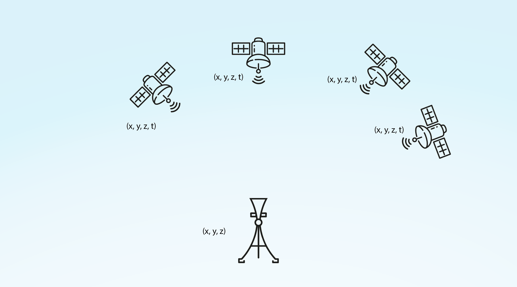
Satellites have atomic clocks that provide extremely accurate dating. The time information is placed in the codes broadcast by the satellite. The receiver then continuously determines the time at which the signal was broadcast. The signal also contains orbitography data so that the receiver can calculate the location of the satellites. This is navigation information.
The GNSS receiver uses the time difference between the time of reception and broadcasting of the signal to determine the distance between the receiver antenna and the satellite. The receiver that receives signals from at least four satellites can accurately determine any 3D location in the visibility of satellites. To do this, it will use the intersection of these satellite-receiver vectors.
Real-Time Kinematic Positioning
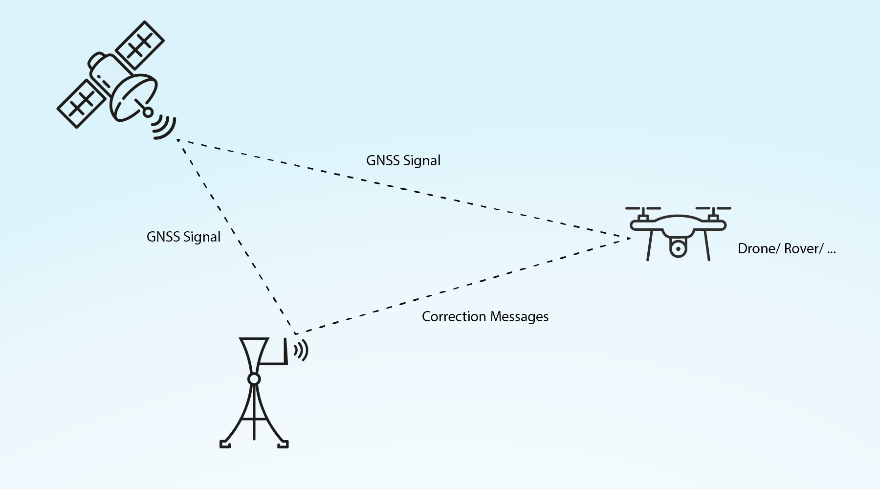
Real-time kinematic (RTK) is a method of enhancing the precision of position data derived from satellite-based positioning systems (global navigation satellite systems, GNSS). It is commonly used in applications such as surveying, construction, and agriculture, where high-precision position data is required.
In RTK, a stationary reference receiver, also called “Base”, is placed at a known location, and a second receiver, also called “Rover”, is carried by the user or vehicle. The base receiver measures the precise position of the satellite signals, and the data is transmitted to the second receiver, which uses the information to calculate its own position with much greater precision than would be possible using the satellite signals alone. Described configuration can assure centimeter precision in location determination.
RTK data and position accuracy can be described with some statistics terms. First one is CEP (circular error probable). It represents the radius of a circle centered on the true position of an object, within which there is a 50% probability that the measured position of the object will fall. In other words, if a satellite-based positioning system has a CEP of 10 centimeters, this means that there is a 50% probability that the measured position of an object will be within 10 centimeters of its true position. Second one is distance root mean square (DRMS) - the radius of the circle in which 68% of the results are located. The last one is 2DRMS - twice the DRMS and it represents a circle in which 98% of the results are located.
Another important parameter is time to first fix (TTFF). It is a measure of the time it takes for a satellite-based positioning system to determine the initial position of a receiver. TTFF is an important performance metric for satellite-based positioning systems, as it represents the time that it takes for the system to be ready for use after it is turned on.
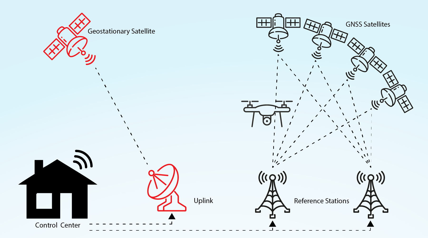
Precise point positioning
Precise point positioning (PPP) is a method of determining the precise position of a receiver using GNSS (Global Navigation Satellite System) signals. Unlike other methods of GNSS positioning, which use a network of ground-based reference stations to provide corrections to the GNSS receivers, PPP uses only the GNSS signals and correction signals from geostationary satellites to determine the receiver's position with high accuracy. A PPP correction service consists of the following components: ground-based tracking stations, analysis software to calculate the orbit, clock and ionospheric corrections and a method of distributing the modifications to users. PPP method is very useful in remote or difficult-to-reach areas.